Latest Tweet

Thursday 22 December 2011

New application for conversion of Aldeburgh Park Road water tower

Suffolk Coastal District Council have posted notices that two new applications C/11/2792 and C/11/2991 have been received for conversion of the water tower at Park Road IP15 5ET where previous applications (references C/10/3260 and C/10/3261) were refused.


The architects believe the new scheme meets the concerns raised by the council and the members of the public with regard to the previous design.


BWTAS won't take sides on planning issues but it does note that the more thorough historical investigation of the tower that was submitted with this application shows that judgements of 'historic significance' and 'architectural merit' are relative and made according to the information available. We're grateful that the tower does have more historic significance than was first suspected with its connection to the transit system of Brooklyn, USA and the colourful William Fontaine Bruff, an emigrant from Essex to that city who made a fortune there in railways, one was called 'Bruff's Road', who was also the designer of the Aldeburgh tower.

William Bruff - water tower engineer

From http://apps3.suffolkcoastal.gov.uk/planningonlinedocuments/125670_6.pdf and other sources:

William Fontaine Golding Bruff (elected associate of the Institution of Civil Engineers on 6 December 1864) was the son of Peter Schuyler Bruff, of Handford Lodge, Ipswich. The elder Bruff (1812–1900) was elected as a Member of the Institution of Civil Engineers on 8 April 1856.

A photo of William's dad Peter is here https://east.veoliawater.co.uk/about-us-our-history.aspx

Peter Bruff was the foremost railway engineer in Essex and constructed the 325 metres long Chappel Viaduct in 1847-9. Bruff formed his own company to extend the railway line from Colchester to Ipswich and he was responsible for the Tendring Hundred Railway and was involved it its waterworks company. While working on the line he began to develop Walton-on-the-Naze as a seaside resort and built its pier, baths and Marine Terrace. He also bought 50 acres of land to found and develop the resort town of Clacton on Sea, Essex, building the pier, the Royal Hotel, the public hall in Pier Avenue and the town centre. Frinton was yet another Essex development interest.

William Bruff was the engineer for the Mid-Suffolk and Southwold Railways in 1865 and it is
likely that the family’s strong presence in Essex and Suffolk as well as their experience of water engineering stood him in good stead when the Aldeburgh Waterworks Company considered the appointment of an engineer. He remained essentially a railway man while he designed and built a water works and the water tower at Park Road, Aldeburgh IP15 5ET. 


In the 1870s he was summonsed to court on a charge of embezzling money from his employers, contractors for the Severn Railway Bridge, but was acquitted for lack of evidence. He appears on a passenger list arriving in New York in 1871. By 1880 he was living in the USA and he became a US citizen. He appears on the incoming passenger list on the Lucania arriving in Liverpool from New York in 1899.

James Blaine Walker in his Fifty Years of Rapid Transit (1918; extract at Appendix B) described Bruff as the most picturesque figure in the history of Brooklyn’s rapid transport system. He "parted his hair as well as his name in the middle. He was one of the early types of the breezy, energetic promoter, and while he spent money lavishly he seems to have had a talent for gathering it in, and is credited with infusing life into the languishing project (Brooklyn Elevated Railway) and bringing about the road's construction. When he finally got the work started he would drive to it each morning in a stylish carriage, with a liveried coachman. He brought bankers into line and for a time funds rolled in upon him at the rate of $90,000 a week. He was elected president of the company in January, 1879."


The railway went through several bankruptcies and reorganisations and W. Fontaine Bruff became legendary for his headlong style in challenging the city aldermen and his rivals which had got him and his workmen arrested when they broke ground for the railway.

It appears that he returned to the UK as sick man and in 1911 was living in south Twickenham under medical supervision.


The Ipswich Journal also records one of their correspondents meeting him in London in 1874. Bruff is chomping on a half cigar and totally absorbed in surveying Temple Bar gate. At that time, the authorities wanted to pull it down as it was impeding the traffic. There were efforts to save the historic gateway and, some years later, it was bought by brewing magnate, dismantled stone by stone, and taken to his country pile in Hertfordshire. After purchase by a trust in the 1980‘s, Temple Bar was dismantled again and re-erected in 2004 at the entrance of the Paternoster Square near St Paul’s in London.

Friday 2 December 2011

China's water history


BWTAS recently received enquiries about images of Shanghai's metal water tower that we have covered in this journal and so were informed that a second steel water tower was built in Shanghai around 1905 by John Taylor and Sons. A drawing of it can be found in Chelsea to Cairo: Taylor-made water through eleven reigns and in six continents - Thomas Telford, London, a history of the engineering firm by Gwilym Roberts.


Dr Albert Koenig of Hong Kong University and co-author Du Pengfei of Tsinghua University would like to enlist the help of BWTAS members and water tower enthusiasts around the world as they are preparing a chapter on the water history of pre-modern China for a book: The Evolution of Water Supply Throughout the Millennia to be published by International Water Association Publishing. This tome is undoubtedly going to be on a lot of this journal's readers' wish lists. 


The authors know another tower, an Eiffel-type hexagonal plan metal construction, was built for the Capital Water Ltd. in Beijing. Unfortunately, they cannot discover anything about its designer or builder. 


Source: Gong shui zhi in: Beijing zhi. Shi zheng juan. Gong shui zhi. Gong re zhi. Ran qi zhi, (2003) Beijing Shi di fang zhi bian zuan wei yuan hui, ed. Beijing chu ban she, Beijing, p. 168ff.

Beijing water tower under construction, Photo taken by Ernst Boerschmann c.1907.
Source: Robert K.G. Temple (1990) Im Land des fliegenden Drachen: Chinesische Erfindungen aus vier Jahrtausenden. Vorwort von Joseph Needham. Gustav Luebbe Verlag, Bergisch Gladbach, Germany. 

This type of tower, with its six legs, seems to sit somewhere somewhere on the road to development of the circular hyperboloid structure. 


It was photographed under construction by the noted sinologist Ernst Boerschmann in 1907, who is well worth looking into as a subject. Between 1902 and 1949 he produced thousands of stunning photographs of China's old and modern architecture and its people.


If you know of any tower of a similar construction, please contact the authors at the email address below* and, if possible, provide the name of the designer.


kalbert (at) hkucc.hku.hk 


(*if you're not a spam bot, you'll know what to do)

Saturday 12 November 2011

Blow me down: a chance to demolish iconic water tower


The final chapter of the saga of the water tower at the former Campbell's soup factory will be written in the local newspaper. The Lynn News is offering readers a once-in-a-lifetime opportunity to push the detonator to demolish it later this month to make way for a Tesco supermarket. No word yet whether this is a BOGOF offer or will get any extra clubcard points.

If you know of someone you think should have this honour, send your nomination by Friday 18th November 2011 to mike.last@lynnnews.co.uk, or by letter to Mike Last, Senior Writer, Lynn News, Limes House, Purfleet Street, King’s Lynn, Norfolk, PE30 1HL.

Sunday 16 October 2011

BWTAS 2012 Calendars

1/12/11 Sorry all 2012 calendars have sold out. Reserve the 2013 edition now to avoid disappointment.


It seems that Christmas comes earlier every year but for the water tower aficionados expecting a 2012 BWTAS calendar in their stocking, it can't come too soon.

BWTAS presents its first ever calendar. In a handy flip-over A3 format, each month has a full colour image of a UK water tower taken by a BWTAS member. 


The print run has been limited to 75 copies (and 20 are pre-sold) so get your order in ASAP and sit back and enjoy the holiday season knowing that shopping for that water tower fan in your life is sorted.


enquiries: postmaster@andynorris8.plus.com

Friday 30 September 2011

180° of Light show


photo by SteveRSVR
180° of Light is a laser installation linking water towers in Rothwell, Desborough and Corby in the British Midlands with laser beams to form a triangle, the alchemical symbol of water. The project is a part of a county-wide series of site specific artworks on  Northamptonshire's rivers, canals, waterways and water towers. There has already been an installation on Northamptonshire's Oxford canal and there will be a further installation at Sywell Reservoir in October. NESTA fellow Jo Fairfax and FLOW manager Graham Callister came up with the idea. Visible from the A14, the project is part of Igniting Ambition Festival and the London 2012 Cultural Olympiad. The lasers shine from 7.30 to 9.30 pm until 2nd October 2011. Its website gives a raison d'etre:

This site-specific artwork highlights the architectural beauty, science and necessity of water towers in today’s society. Among their many uses, water towers provide pressure to maintain the safety of the water supply, without which water may not spray from a tap with sufficient FLOW.

By using several strikingly bold lasers, this site-specific, large scale installation produces a formal dynamic between the imposing circular drums of the water towers and the stunning, elevated triangle of light which unites them. Dominating the Northamptonshire landscape, 180° of Light encourages conversations both of architectural form and journey.

The artist, Jo Fairfax, described the installations:

“Creating a giant laser triangle hovering in the sky makes me smile. Each water tower forms the corner of the laser triangle creating a conversation in form - the circle of the water drum with the triangle of light. The journey of light is evident and the journey of water is implied, another conversation. The moving striated visual effect created as the laser light breaks down over distance implies a sense of journey. The water tower drum containing water held high, water reader to enter and exit, implies a journey. The two meet either side of the water drum. Both dynamic, one in its speed and break down, the other in its potential and pressure. Water and light, like siblings with a story to tell”.

Key funders included Arts Council England, Legacy Trust UK, Northamptonshire County Council, Anglian Water and Breath of Fresh Air, East Midlands.

More information about FLOW


BBC news slideshow http://www.bbc.co.uk/news/uk-england-northamptonshire-14983682


Here's map of the laser 'field' to aid viewing:


View flow towers in a larger map


BWTAS context:

Illuminating water towers has a long history and was commonplace when water towers were novel and objects of civic pride. The Thorpe Hamlet water tower in Norwich was illuminated for a year to commemorate George V's silver jubilee in 1935. A couple of generations later, illumination of towers was used as way of reasserting their monumental quality and renewing civic pride as part of regeneration schemes. Cranhill Arts Project in Glasgow illuminated their local tower a vibrant green with white spotlights and nearby the Craigend water towers were illuminated as part of Glasgow's reign as the European City of Culture. The city council's lighting strategy webpage asserts: "Good lighting helps to increase vitality and improve ambience. It contributes to a sense of identity and place, makes for a safer, friendlier environment and also supports and complements other regeneration initiatives."

Friday 23 September 2011

Tower hunting in British Columbia


While on vacation in British Columbia this month I was given a driving tour of the sights of the city of Victoria. When we stopped at Government House intending to eat our sandwiches in its splendid gardens, the cooler we had brought along was empty. The sandwiches had been made but left behind on the kitchen counter; the cook thinking the driver would pack them, the driver thinking the cook had packed them. While we made do with the dessert, my companions asked if there was anything in particular I wanted to stop and look at. A few minutes earlier I had glimpsed a water tower atop a distant hill so I said, if they didn't mind, that I'd like to take a look. "But", I warned them, "towers are shy creatures. If you go looking for them, they tend to run away..." 


After stopping at the marvellous outdoor retailer Mountain Equipment Cooperative, we surmised from our map it must lie in the region of the Craigdarroch Castle so we headed there. Navigating the one-way system we came to the coal mine owner's mansion - scene of a legendary and lengthy family dispute - which is now a museum and walked around outside but were unable to see the tower from this vantage point. "It saw us coming" I told my companions. The 'castle', though imposing, is more a sandstone pastiche of Scottish laird and Disney fairytale but it was impressive that every window, including sash ones, and each door was carved to follow the curve of the turrets, a 'hang the cost' detail but with admission costing $13 pp, I have no doubt their upkeep is expensive.


The mansion is in the area called Rockland which was once Victoria's 'Nob Hill' and now an open-top English bus plys guided tours pointing out the mock-Tudor piles of other migrants who made their fortunes in lumber, furs, coal and construction in this last frontier and bastion of the British Empire. Though we couldn't see it, I suspected the elusive tower must be nearby as we were on a plateau and the tower must have been constructed to serve all these grand homes. We set off down the hill to backtrack to where I had first seen the tower, hoping that then we could then turn around and stalk towards it like a game of Grandmother's Footsteps. 


Perhaps it felt like only playing peek-a-boo with us because as we drove away, we suddenly saw it looming over some houses. It was then a case of my jumping out with a camera to capture a view and try to find a way to walk to its base while my companions waited in the car, as they did not want to enrich the city with a parking fine nor be an accessory to any inadvertent trespass. Besides, a large party would likely scare it off again. It was a process of elimination in going up successive driveways, each tantalisingly appearing to lead to the base, to find the one which its attendants must have used to reach the door.


The tower sits rather dilapidated and unused in the garden of a old mansion which is now apparently a multiple rental/condo. Given that access to the tower must have some easement over the driveway, I ran up to the base to log the tower on my GPS device. We then quickly took our leave to visit one of Victoria's many coffee shops, the boho-style Tooks on Cook we had passed earlier. Here very satisfactory sandwiches and slice of quiche with a salad was not as elusive.


View MEC to tower expedition in a larger map


Tower Location: Laural Lane, Victoria B.C. Canada.
Built: 1908. Decommissioned: 2000 
Height: 33.22 m.
Capacity: 412,330 litres. 


The tower is an unreinforced 25.4 cm. thick concrete cylinder of 6.71 m. inside diameter, 21.34 m. high, supporting a 11.89 m. high water tank of equal diameter. This is a balancing reservoir. The tower can be clearly seen from the ocean and has been used as an navigation aid by small craft.


The 128-foot water tower was built by the famous contractor Henry Kaiser. In 1962, to commemorate the centenary of Victoria, the tower was topped by a 22-foot tall neon flame, which burned for over 25 years.


From Victoria Heritage Foundation


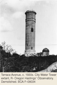
 With Victoria’s population growing rapidly, the city water supply was quickly becoming inadequate, and 1909 saw construction of a 100,000-gallon concrete water tower. This must have seemed unsightly, among the villas and Garry oak meadows at one of the highest points of Rockland, but, along with the Smith Hill Reservoir, it constituted a stop-gap project to supply Victorians with water until the new system at Sooke Lake was built. The area around the water tower was known locally as Observatory Hill.

It featured a large, Queen Anne house called Observatory Villa with a 3-storey tower and a small observatory, which was built by amateur astronomer Oregon Columbus Hastings in 1890 (915 St. Charles Street, demolished). By 1903, the lane leading to the observatory had been officially named Observatory Hill.

Thursday 22 September 2011

Water tower film wanted by TV programme

UPDATE

This programme will be transmitted on Thursday January 12, 20102 at 9pm on Channel 4.

--

Television programme "The Restoration Man” on Channel 4 are desperately looking for film footage shot between the 1900s-1930s showing  any 19th century Water towers across Britain. Their programme is focussing on the Forge Lane Water Tower in Congleton, Cheshire but notwithstanding finding any film of that, they would like footage that shows the interior of any 19th century water tower with it’s water pump in action etc. 
Forge Lane
Some possible towers could be:

  1. Court Lodge Water Tower. Wrotham, Kent. 
  2. The Round House, Perth, Tayside, 1832 
  3. Everton Water Tower, Liverpool, Merseyside, 1854 
  4. Internally Flanged cast iron tank, Wivenhoe water tower, Essex, 1901 
  5. Flaybrick water tower, Birkenhead, Merseyside, 1865 
  6. Friday Bridge water tower, Wisbech, Cambridgeshire, 1894 
  7. Westgate water tower, Lincoln, 1910 
  8. Lymm water tower, Cheshire.
  9. Horncastle Road Water Tower, Boston, Lincolnshire, 1905 
  10. Hartlepool water towers, Cleveland 
  11. Balkerne Tower, Colchester, Essex, 1882 
  12. Winshill water tower, Burton on Trent, Staffs, 1907 
  13. Rockwell Green water tower, Wellington, Somerset, 1885
If you have any information about film footage please contact:

Jane Elizabeth Higgs
Archive Research
The Restoration Man
Tiger Aspect
0207 544 1649

Saturday 10 September 2011

The Zandvoort towers

From this...


to This.

During World War II, our water towers were not attacked by enemy action, as we now know, the Luftwaffe used these landmarks as aid to navigation - the Dutch were not so lucky. The elegant, reinforced concrete tower on the left, by architect J. van Poelgeest and dating from 1912, was blown up on 17th September 1943, by the occupying forces.

A new 48 metre high water tower that has a brick façade covering its reinforced concrete structure, was erected between 1949 and 1951 from a design by J. Zietsma. It was originally conceived as a round tower but ended up being an octagonal. The tower with two tanks with a total volume of 209,000 gallons came into service in 1952.

Images of construction of the reinforced concrete tower may be found here. The new tower is located at 52º 22' 13" North, 4º 31' 30" East, the old tower was located about ¼ mile to the North.

Any body who has more information on these towers, please leave a comment.


Ferrers

Tuesday 23 August 2011

Elveden Visit

update 2/9/2011: visit now fully booked

Lord Iveagh has kindly granted permission for BWTAS to visit the Elveden Water Tower, a Grade II listed structure from 1895 and one of the most ornate and imposing examples of a Victorian estate tower in the UK.

Wednesday 12th October, 11.00am. Meet at the Estate Offices, London Rd, Elveden, Thetford IP24 3TQ.


Anyone planning to attend MUST let Wil Harvey know before on 01502 478248 or harveys@care4free.net ASAP, as the estate must have names beforehand. There will be no admission otherwise.

Booking priority is given to BWTAS members, then to the public. Space is very limited. We'll announce any changes and further information here and on twitter @bwtas. Non-members can join the society on the day.

Please note all the usual disclaimers apply: this is a industrial building not normally open to the public, it is not suitable for young children, there is no disabled access and the visit is at the visitor's own risk and subject to the directions of the Elveden estate.


For companions not interested in water towers, there is a shop and restaurant on the estate www.elveden.com

Monday 8 August 2011

Park Hill, Croydon (1867) - Update


Further to my comments on Croydon Water Tower, I have found additional information regarding this tower, from a copy of “Engineering” 5th June, 1868. The etching above (click picture for a larger image) comes from Google eBooks and is accompanied by the following text on page 545, that I have transcribed here, as it is a little difficult to read:

Croydon water tower, of which we give engravings on page 543, was erected last year for the Croydon Local board of health, from the designs of Mr. Baldwin Latham C.E., the engineer for the public works of Croydon, by Mr. J.T. Chappen, contractor, of Steyning, Sussex. It was constructed in order to furnish a supply of water to the high level district of Croydon. The tower is a brick building in the Northern style, containing a reservoir in the base which will hold 94,000 gallons of water. This lower level reservoir is on the same level and in connection with the reservoir used to supply water to the low level districts of Croydon. The upper tank in the tower holds 40,000 gallons, and the supply of water for it is taken from the lower reservoir and pumped by a rotary steam engine to the high level. The summit tank is of wrought iron, and the shell is made of ¼ in. plates of iron, strengthened at the horizontal joints with T iron, and the bottom is of ¾ in. plates. The tank is supported partially on the external walls and partly on three hollow central columns, one of which serves to furnish a supply to the high level district, whilst the second forms of the rising main from the engine house, which has been constructed at the foot of the tower, and the third acts as an overflow.
Our engraving includes a perspective view, together with a vertical and two horizontal sections. From these sections the construction of the tile will clearly will be clearly seen. The basement portion forming the lower tank is 27 ft. in diameter inside, and the Water stands in it to a depth of 27 ft. In the centre is a brick pier with stone capping, forming the base of the three central columns already mentioned, and around this the bottom of the reservoir is formed by a brick invert, as above. The bottom rests upon a bed of concrete 4 ft. thick, this concrete being laid on a clay substratum at a depth of 25 ft. below the general ground level. At the bottom of the lower reservoir the walls of the tower are 5 ft. 5 in thick, and the thickness is gradually decreased to 3 ft. 6 in. at the level of the surface of the water. Above this level the thickness of the Walls is diminished from 3 ft. 2 in. at the level of the basement floor to 14 in. at the top of the tower. The lower part of the tar forming the lower reservoir is surrounded by puddle backing, as shown, this backing being carried down to the bottom of the concrete. The total height of the tower, from the bottom of the concrete to the top of the turret, is 125 ft., the top of the turret being thus 100 ft. above the general ground level. The top of the tower itself is 10 ft. lower, or 90 ft. above the ground level. The general design of the tower is exceedingly good, and it is its appearance is very effective. In conclusion, we should state that our engravings have been prepared from a photograph and drawings kindly supplied to us by Mr Latham.

This water tower is located at TQ 33052 65002.

Ferrers

Saturday 23 July 2011

Wassertürme

This is brilliant - Tim Taylor is building scale matchstick models of all the water towers illustrated in the Hilla and Bernd Becher's book "Wassertürme"! This fantastic book covers water towers in Europe and the U.K. and some from America too. The towers are being built at precisely the size they appear in the Becher's plates, within the book. Hence they are not actually in scale with each other, but are all of a similar size. Tim is transforming their photographical record of the water towers into his own reality, so to speak. Wassertürme is also available in English (ISBN 026202277X) it was dubbed the "Old Testament" at the last BWTAS meeting (Barry Barton's book being the "New Testament").

The exhibition is on now and runs until 29th July, and is on at 36 St. Mary's Street, Edinburgh, EH1 1SX. Details can be found here. A sample of Tim's towers are presented below...

Saturday 2 July 2011

Ormskirk water tower owner seeks information, offers access...


image lifted from http://www.uniquepropertyblog.co.uk 
Last Thursday, Mike Jones and his friend became the proud owners of the Ormskirk Hospital water tower in West Lancashire.


Now Mike is asking if BWTAS members know anything of its history. All he knows is that it was built in 1860 to provide water to the Poor Law workhouse that then became Ormskirk Hospital in the 1950's.


Mike's taken up the standing offer of complimentary membership of BWTAS to tower owners and he would be happy for members to come and look around before they start conversion although he and BWTAS can't accept any liability for injury etc. In today's litigation culture we are compelled to say that.


Mike's also looking for guidance from any qualified members whilst he plans what to do with this fantastic building.


Please contact him on mjhousebuild@tesco.net or mobile 07751 605384. The tower is off Nightingale Walk, postcode L39 2AZ.


Prior to the sale, Burcough-based property specialists Armistead Barnett were saying they expected the demand for this property to be high.


Sales manager David Cowburn told the Ormskirk Advertiser: “This is an iconic, landmark building which offers a fantastic opportunity for those looking to create their dream home. The Water Tower is of particular architectural interest due to its five storeys, side projectile pipes, arched windows and the large water tank on top. Planning permission has been granted for two flats but there is potential to create one huge five-storey residence. It will make for a stunning home.”


The 175 square meter tower was part of the hospital site purchased and developed by Persimmon Homes as Nightingale Walk.


Nearby residents aslo said they were in favour of the developement. Neil Wynne, of Pinfold Road, said: "I would prefer it if someone moved into the water tower."


Ormskirk is also known for another water tower, the concrete 'UFO' at Scarth Hill to the east of Ormskirk. 


Sadly there is also a very large derelict one at Greetby Hill, now obviously a missed development opportunity but in its dotage has become reminicsent of a Victorian folly. An application to convert it into seven apartments in 2001 was later withdrawn. Greetby Now  and Then.


Thursday 30 June 2011

The ultimate project?: Cold War water tower up for sale


When Southern Water unloaded a portfolio of properties in 2004, architect Stephen Luxford purchased the Braithwaite water tower at the former Greenham Common airbase and then got planning permission to convert it into a house. That was a bit of a shock to the local council as they expected buyers would cut it up for scrap and put a traditional house on the plot.

We haven't heard anything for a while but Stephen has just been in touch to tell BWTAS:

"I’ve had the planning extended to 2013 and due to my business being London based, I have given up on carrying the scheme forward myself and the tower is going to auction on 27th July 2011 with www.romans.co.uk – guide price £50,000. "

Stephen told BWTAS before that a build cost estimate is tricky because of unusual nature of the build but at £1200 to £1500/m.sq (quite a high rate) it would be in the region of £160k to £200k.
The auction listing is at http://www.romans.co.uk/Property/40980


Water tower gets robo-clean


First Water Tower Robot Clean for Panton McLeod


29th June 2011


Water quality engineering firm Panton McLeod has completed another first in its work within the UK’s water sector after cleaning a storage tower with robotic technology.


The firm used its VR600 cleaning robot to clean the interior of a water tower in Wiltshire for Wessex Water while it was still active and in service, ensuring minimal disruption for customers in the region.

The project at Minety Tower near Wootton Basset represented the first time that Panton McLeod has ever used the innovative machine to clean an elevated water storage structure in the UK.
In order to access the facility, the firm had to hire a crane in order to lift the robot to the top of the 35 meters high tower before disinfecting the machine and lowering it into the structure.


A team of operators then manoeuvred the remotely-controlled machine throughout the interior of the structure – in order to remove any build up of natural materials on the floor of the facility. The routine work ensures that the drinking water stored in the tower remains at the highest quality levels.


Paul Henderson, operations director at Panton McLeod, said: “We regularly use the VR600 machine for cleaning service reservoirs and storage tanks across the UK. In recent years, the machine has been a vital part of our work for some of the biggest companies in the water sector, including Scottish Water and Severn Trent Water.

“However, before the project at Minety Tower, we had never used the robot to clean a water tower. It represented a big challenge for our underwater team, but we were able to use our expertise to ensure that the project was a success.


“The most challenging aspect was lifting the robot to the top of the 35 metres tall tower in the first place, so we could insert it into the facility and start the cleaning process. We had to hire a special 55 tonne crane to hoist it to the top, but once this was complete, the rest of the project was fairly straight forward.


“We’re delighted with how smoothly the whole cleaning process was carried out, and proud of our team who ensured that this challenging job was completed swiftly. We’re always happy when we identify new ways to deploy our technology, and we hope that this project will lead to more water tower cleans in the future.”


The VR600 is a special tracked robot that is manoeuvred along the floor of any water storage structure and removes any sediment build up on the floor of the structure. It can also be used to inspect the condition of the water tanks, including checking the walls and interior of the facilities for corrosion or damage.

Panton McLeod also uses a specialist ROV inspection robot which is manoeuvred like a submarine through the water in a service reservoir and is able to inspect the walls of the tank, joints, and the roof soffit for damage or leakage.

Both machines are remotely operated from the surface and fitted with cameras and lighting equipment, allowing staff controlling the sub to assess the interior of the tanks. They are also used solely within clean potable water environments and meticulously cleaned and disinfected prior to every use to ensure they can be safely used in the public water supply, and Panton McLeod conducts rigorous tests before and after each inspection.

More information about the machines and Panton McLeod’s other services for the UK water sector can be found at their
website

--


You can see the VR600 in action on YouTube


Water tower tanks are traditionally cleaned and serviced by taking them offline, draining them and then sending workers into the tank via the access hatches to sweep and flush the built-up sediment down the overflow/waste line by hand. Sometimes a small rowboat was lowered inside for inspections. We suppose the health and safety regulations now make the cost of cranes to lift robot vacuums (basically high-tech pool cleaners) into the tank a cheaper option.


Monday 27 June 2011

East Anglia's water tower history


Water tower development is driven as much by social reforms as the progress in civil engineering and it is also driven by improvements in the technology of building materials, pumping machinery, steam engines and pipe making.


From their aqueducts the Romans used bucket-chain pumps powered by animals and slaves to fill raised cisterns with clay or wooden pipes for local water distribution. The foundations of Roman water towers have been discovered at Ixworth and in the City of London. At Vindolanda in Northumberland, wooden pipes over 2000 years old were found still working. 


Many Medieval castles and monasteries had stone towers lined with clay or lead as a strategic supply. Lendal Tower in York was once a water tower. Though many castles - like Chester - have a tower called 'The Water Tower', this is misleading. It is because they are gates accessible by water.


Wind and water driven pumps began to appear in the late 16th century. A ‘forcer’ pumping water “to the highest parts of the city” was recorded in Norwich in 1583.


One of the great early water engineers was George Sorocold (1668 - 1717) of Derby who also built water systems for Norwich, Bristol, Leeds and London but we know very little about his life. 


Many landscape artists painted the York Street water tower of 18th Century London which was pumped by a paddle wheel in the Thames.


The Industrial Revolution (1760- 1830) brought a huge demand for water and advances in iron and steel manufacturing. Water towers became landmarks alongside engine houses, chimneys and factories in our towns and cities.


Water towers present many engineering challenges. The search for affordable materials and methods that can resist the relentless force of gravity acting on water has stimulated progress to this day.


Ferro-concrete was  first invented for building water towers by the French engineer Francois Hennebique in 1892.


Water tower styles reflect the architectural movements of their time. Horstead in Norfolk was a bold experiment in 60’s modernism because its designer thought the planners and local people wouldn't want to see "another baked-bean tin on legs". The earliest of many concrete towers in Suffolk built between 1930 to 1950 by the Vibrated Concrete Company have ornamentation reflecting the new streamlining seen on ships and locomotives. Later towers, keeping to the same basic layout, have ornamentation of a more angular pattern. Plotting the dates of construction reveals that hints of Art Deco morph into touches of Bauhaus and the angular singularity of Le Corbusier.


According to English Heritage; at one time the "the water industry in England was of the greatest international importance ... many of the solutions adopted in Europe and North America were first devised in English towns."


After a fire destroyed Hamburg in 1842 because the water supply had failed, the Kaiser of the day had British engineer William Lindley (1808-1900) built several towers for the new water system. Lindley went on to work for many other European cities. A street in Budapest commemorates him. The attractive water tower in Epping High Road is his work.


The cholera epidemics of the mid 19th century and the ‘Great Stink’ of London in 1858 convinced Parliament that Britain’s water supply needed a complete overhaul. Victorian engineers like Joseph Bazalgette (1819 - 1891) built large metropolitan water systems and many water towers. Meanwhile, a rapidly expanding railway network with its need for a water tower every ten miles for steam locomotives; spurred the development of large-scale metal pre-fabrication which then lead to advances in bridge and building construction.


This period up until 1930 is considered the golden age of water towers. Worldwide demand encouraged research and development as British civil engineers got plenty of orders for successful designs from Shanghai to Sudan.


Despite progress in the cities, waterborne diseases were still common in rural areas where local governments could not raise the capital investment required to prevent the pollution of boreholes or rivers supplying the community from the effluent of domestic cesspits.


Some remarkable water towers were built by landowners, schools and asylums but in 1910, two thirds of rural parishes in England still had no piped water. 


In 1944 the rural water boards obtained by an act of parliament the public investment they needed for a long period of post-war tower building but in some towns, people campaigned to stay 'dry' rather than have any increase in their rates.


During the Second World War, East Anglia’s strategic position caused a great number of prefabricated steel towers to be built for military installations, most commonly the Braithwaite system of bolted panels still made today, but there are others. Afterwards some were adopted for the public supply and remain in use but it took until the mid-sixties to connect every town and village in East Anglia to mains water. 


The future of water towers in East Anglia likely lies in their imaginative reuse. 


Opinion can vary widely if they are assets or blights to the skyline. Their visibility does give them commercial value while some styles can present challenges to convert for occupation but few people can resist an offer to see the view from the top of one and they are eagerly sought out by people looking for a restoration challenge or unique homes.


Disused towers have become homes, offices, performance venues, sports facilities and tourist attractions but their potential has yet to be fully exploited.


© Nat Bocking

Monday 30 May 2011

Take a little, give a little more back


Water tower hunters are incredibly grateful for the modern tools of online maps and user-contributed maps available today. In the old days, desk-based research consisted of painstakingly poring over paper maps grid square by grid square, noting any instance of 'wr twr' with the certain knowledge that many towers that were marked therein didn't exist any more and many more towers stood majestically but entirely unmarked.


The reasons for this are varied; sometimes they were simply misclassified or missed by the cartographer when the photo survey took place. Or their omission was for reasons of security of the public water supply or that their presence indicated activity which someone would prefer the public knew as little about as possible. Besides their appreciation, unimpeded access to accurate data on water towers has been the raison d'être of BWTAS.


To find towers in the first place, there is now a dizzying array of resources such as Geograph, Flickr and Panoramio that enable people to post for example their travel photos and pin them to a map with exact coordinates. These sites have thousands, perhaps millions, of water towers images as they never seem to fail to attract attention of photographers however, there is the drawback that such user-generated content does vary in quality.


The iconic water tower in Thorpeness, Suffolk known as 'The House in the Clouds' is variously marked up to a quarter mile from its actual location and by many names such as 'The House in the Sky' and, though a minor detail, it is often described as a converted tower when it was purpose-built to be a home that happened to have a huge tank on top. Such mis-information then gets parroted by other web-hunters and also makes its way into printed tourist guides and becomes a 'meme' that is impossible to correct.

What's still missing from the web though is some way of recording all the other 'meta' data about a water tower along with its location and images of it from various viewpoints. BWTAS are not aware yet of a resource - except for Britain's listed structures - that allows recording of all the pertinent details of British towers that could be searchable by form, date of construction, materials, designer, owner and so on along with its location coordinates and images. It would be very handy to have something that could hold all the various kinds of water tower data, from addresses to the ISBNs and reference numbers of sources. If you know of such a tool, please comment or get in touch as many people in the water tower fraternity think Britain's water infrastructure deserves an online database like the Defence of Britain Project.


In the meantime, the BWTAS committee would like to encourage our members and the world at large to show gratitude for the availability of these free resources and so when we take a little, to give a bit more back by contributing to what's out there. As there are so many resources, a bit of discrimination should be considered as to what is worthwhile to support. In the UK the site Geograph has a 'critical mass' of water towers and so new towers should be added there as it is quickly becoming a definitive list.


If you know of a water tower-related museum, heritage site or a water tower open to the public, it would be helpful to get it listed under 'attractions' in the databases Sat Nav manufacturers pre-install such as the Tele Atlas GPS POI database. POI databases are becoming more and more important all the time and have become the de-facto Yellow Pages ® while people are on the move.


The process is easy, just point your browser to the multi-language Tele Atlas Map Feedback web site and follow the 3 easy steps to somewhere listed or have an incorrect listing changed. This site allows you to enter a location by coordinates or post code but the coding of the point of interest for a water tower is limited to 'other'. One drawback on this site is that it doesn't provide much evidence for locating the precise location. You can drop a pin anywhere on the map but it's best to already have the location coordinates written down before you use the site to enter them.


While you’re adding a heritage site to Tele Atlas you can also add it to the NAVTEQ POI Database too. This site has a lot more detail and the maps can switch between satellite images and graphics so you can be sure you are pinning the right place. At the time of writing only one water tower at King Faisal St, Al Foutah, Riyadh, Saudi Arabia was listed there.


And, if your community is plagued by HGVs getting stuck in narrow lanes because of reliance on the driver's sat nav, (which is common issue vexing parish councils in Suffolk) then you can record the actual road restrictions on the NAVTEQ site as well, which should re-direct inappropriate traffic away in the future.


Although you are basically working for free for entity who are profiting from your effort, if you have a vested interest in water towers in some way, then it's well worth the trouble to let other people know exactly where these points of interest are.


For more esoteric data, perhaps purely to record the existence of a structure which the OS Map has omitted, an extremely useful resource is OpenStreetMap, a free editable map of the whole world. It allows you to view, edit and use geographical data in a collaborative way from anywhere on Earth. This site is hosted in London at the UCL VR Centre for the Built Environment.


Here is an incredibly nifty video showing how quickly mapping of the Earth has been done by crowd-sourcing since the project began in 2004.


OSM 2008: A Year of Edits from ItoWorld on Vimeo.


At the time of writing this there were only fifty or so towers marked on the Open Street Map, mostly in the USA. Whilst the learning curve to be a map contributor here is steep, it is a short hill. Most importantly, this resource has enormous credibility and is being used in developing countries and by governments to assist all manner of planning and development which mapping for would otherwise be impossible and unaffordable. Just as the reigns of power were snatched from his hands, erstwhile prime-minister Gordon Brown released the British Ordnance Survey base map to OSM to enable the mapping of the United Kingdom.


Water tower fans should be contributing OSM because people are able to use the data in print publications and websites for free whereas it typically costs £50 to license OS data in a small leaflet or website. So for a body wanting to publish a pamphlet of a local heritage trail, that cost, in practise, rather impeded such initiatives.

Friday 27 May 2011

Tell me, where do you come from my Cotton Eyed To (wer)?


In 1915, when its population was about 1600, the city of Cotton Plant Arkansas USA was the birthplace of one of the greatest ever Americans, Sister Rosetta Tharpe.

A fine documentary recently shown on the BBC about Sister Rosetta opens with views of the water tower, bearing the proud name "CITY OF COTTON PLANT". It's a fairly ordinary water tower and it never supplied water to the home of this great American artist.

It turns out that the present steel water tower was built with funds from the PWA (Public Works Administration, an agency of Roosevelt's New Deal) in 1935. It replaced an earlier water tower which would have been serving the city at the time Sister Rosetta was born.

At the age of six she was taken by her evangelist mother Katie Bell to Chicago to join Roberts Temple, Church of God in Christ, where she developed her distinctive style of singing and guitar playing. 

At the age of 23 she left the church and went to New York to join the world of show business, signing with Decca Records. For the following 30 years she performed extensively to packed houses in the USA and subsequently Europe, before her death in 1973.

In 2008 the state governor of Pennsylvania declared that henceforth January 11th will be Sister Rosetta Tharpe Day in recognition of her remarkable musical legacy.


The present Cotton Plant water tower - beside the town's derelict one room jail - is being nominated to the National Register of Historic Places with local significance under Criterion C as a good example of a 1930s water tower. The Cotton Plant Water Tower is also being nominated to the National Register under Criterion A for its associations with the activities of the PWA in Woodruff County during the 1930s. The Cotton Plant Water Tower is being submitted to the National Register of Historic Places under the multiple-property listing “An Ambition to Be Preferred: New Deal Recovery Efforts and Architecture in Arkansas, 1933-1943.


Sanborn Fire Insurance Company noted in its first map of Cotton Plant that the small, eastern Arkansas city had a four inch main running a short distance along Main Street. This water main served eight one inch hydrants used solely for sprinkling the unpaved street. One water tower, sixty-three feet above ground, held 23,000 gallons of water to help keep the dust to a minimum in this quickly growing town. This first water tower was behind a blacksmith shop north of Main Street and west of Ammon Street in the middle of the block. Though the population, 900 in 1908, reached 1,661 by 1920, the city continued to maintain this simple water system and 23,000 gallon tank. More information from Arkansas Historic Preservation Program


Cotton Plant was first called Richmond and was sparsely settled as early as 1840. William Lynch was the first man to build a store in the area, settling here from Mississippi in 1846. After unsuccessfully seeking application for a post office by the name of Richmond, the town settled on Cotton Plant in 1852. Lynch’s store attracted others and soon the village became the center of economic activity in this relatively isolated part of Woodruff County. It was not until 1887 that the town was formally incorporated.